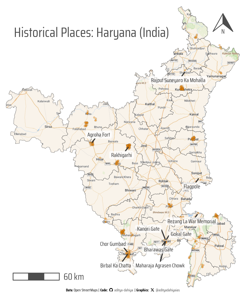
Using {mapview} to make interactive maps in R

Combining {mapview} with {osmdata} and {osmextract} along with geocomputation with {sf} and {terra}

Maps
Open Street Maps
{osmdata}
{osmextract}
India
Haryana
Author

Aditya Dahiya

Published

April 10, 2025

Load packages

Code
# Spatial data handling
library(sf)         # Import, export, and manipulate vector data
library(terra)      # Import, export, and manipulate raster data

# ggplot2 extensions
library(tidyterra)  # Helper functions for using terra with ggplot2

# Data wrangling & visualization
library(tidyverse)  # Data manipulation & visualization
library(mapview)    # Interactive Maps
library(leaflet)    # Extensions to mapview
library(leafpop)    # Pop-up customization

library(osmdata)    # Getting Open Street Maps data

# Final plot tools
library(scales)               # Nice Scales for ggplot2
library(fontawesome)          # Icons display in ggplot2
library(ggtext)               # Markdown text in ggplot2
library(showtext)             # Display fonts in ggplot2
library(patchwork)            # Composing Plots

Getting data

Code
# Get Haryana Map from GADM / {geodata} with geodata::gadm()
# District Wise Map
# haryana_map <- geodata::gadm(
#   country = "India",
#   level = 2,
#   path = tempdir()
# ) |> 
#   st_as_sf() |> 
#   janitor::clean_names() |> 
#   filter(name_1 == "Haryana") |> 
#   rename(district = name_2) |> 
#   select(district, geometry)
# 
# # Overall Boundary Map
# haryana_boundary <- geodata::gadm(
#   country = "India",
#   level = 1,
#   path = tempdir()
# ) |> 
#   st_as_sf() |> 
#   janitor::clean_names() |> 
#   filter(name_1 == "Haryana") |> 
#   select(geometry)

# Survey of India Map
haryana_soi_map <- read_sf(here::here("data", "haryana_map", "HARYANA_DISTRICT_BDY.shp")) |> 
  janitor::clean_names() |> 
  mutate(
    district = str_replace_all(district, ">", "A"),
    district = str_replace_all(district, "\\|", "I"),
    state = str_replace_all(state, ">", "A"),
    district = str_to_title(district)
  ) |> 
  select(district, geometry) |> 
  st_transform("EPSG:4326")

# Get historical sites in Haryana (India)
haryana_raw_historic <- opq(st_bbox(haryana_soi_map)) |> 
  add_osm_feature(
    key = "historic",
    value = c("archaeological_site", "building", "castle",
              "church", "city_gate", "fort", "house",
              "monument", "ruins", "temple")
  ) |> 
  osmdata_sf()

haryana_historic <- haryana_raw_historic$osm_points |> 
  st_intersection(haryana_soi_map) |> 
  select(osm_id, name, district, geometry) |> 
  st_transform("EPSG:4326") |> 
  mutate(
    name = snakecase::to_title_case(name)
  )

Plotting a static map

Code
# Visualization Parameters

bts = 12 # Base Text Size
sysfonts::font_add_google("Saira Condensed", "body_font")
sysfonts::font_add_google("Saira", "title_font")
sysfonts::font_add_google("Saira Extra Condensed", "caption_font")
showtext::showtext_auto()
# A base Colour
bg_col <- "white"
seecolor::print_color(bg_col)

# Colour for highlighted text
text_hil <- "grey30"
seecolor::print_color(text_hil)

# Colour for the text
text_col <- "grey20"
seecolor::print_color(text_col)

theme_set(
  theme_minimal(
    base_size = bts,
    base_family = "body_font"
  ) +
    theme(
      text = element_text(
        colour = "grey30",
        lineheight = 0.3,
        margin = margin(0,0,0,0, "pt")
      ),
      plot.title = element_text(
        hjust = 0.5
      ),
      plot.subtitle = element_text(
        hjust = 0.5
      )
    )
)

# Caption stuff for the plot
sysfonts::font_add(
  family = "Font Awesome 6 Brands",
  regular = here::here("docs", "Font Awesome 6 Brands-Regular-400.otf")
)
github <- "&#xf09b"
github_username <- "aditya-dahiya"
xtwitter <- "&#xe61b"
xtwitter_username <- "@adityadahiyaias"
social_caption_1 <- glue::glue("<span style='font-family:\"Font Awesome 6 Brands\";'>{github};</span> <span style='color: {text_hil}'>{github_username}  </span>")
social_caption_2 <- glue::glue("<span style='font-family:\"Font Awesome 6 Brands\";'>{xtwitter};</span> <span style='color: {text_hil}'>{xtwitter_username}</span>")
plot_caption <- paste0(
  "**Data**:  Open Street Maps",
  "  |  **Code:** ", 
  social_caption_1, 
  " |  **Graphics:** ", 
  social_caption_2
  )
rm(github, github_username, xtwitter, 
   xtwitter_username, social_caption_1, 
   social_caption_2)

size_var = 1000

# A base raster map for Haryana
library(ggmap)
basemap_bbox <- st_bbox(haryana_soi_map)
names(basemap_bbox) <- c("left", "bottom", "right", "top")
# register_stadiamaps()
base_map <- get_stadiamap(
  bbox = basemap_bbox,
  zoom = 9,
  maptype = "outdoors"
)

base_map_plot <- base_map |> 
  rast() |> 
  crop(haryana_soi_map) |> 
  mask(haryana_soi_map)

# Actual Plot ------------------------------------------------
g <- ggplot() +
  geom_spatraster_rgb(
    data = base_map_plot,
    maxcell = Inf
  ) +
  geom_sf(
    data = haryana_soi_map,
    fill = NA,
    linewidth = 0.1,
    colour = "grey30"
  ) +
  geom_sf(
    data = haryana_historic |> st_jitter(0.025),
    alpha = 0.4,
    size = 0.8,
    fill = alpha("darkorange", 0.5),
    pch = 21,
    colour = "grey10",
    stroke = 0.1
  ) +
  ggrepel::geom_label_repel(
    data = haryana_historic,
    mapping = aes(label = name, geometry = geometry),
    stat = "sf_coordinates",
    family = "body_font",
    colour = text_col,
    size = bts / 2,
    fill = alpha(bg_col, 0.7),
    label.size = NA,
    label.padding = unit(0.15, "lines"),
    force = 0.1,
    force_pull = 10,
    min.segment.length = unit(0, "pt")
  ) +
  ggspatial::annotation_north_arrow(
    location = "tr",
    height = unit(size_var / 50, "pt"),
    width = unit(size_var / 50, "pt"),
    style = ggspatial::north_arrow_orienteering(
      line_col = text_hil,
      text_col = text_hil,
      text_family = "body_font",
      fill = c(bg_col, text_hil),
      text_size = bts * 1.5
    )
  ) +
  ggspatial::annotation_scale(
    location = "bl",
    bar_cols = c(bg_col, text_hil),
    text_family = "body_font",
    text_cex = bts / 5,
    text_col = text_hil,
    line_col = text_hil
  ) +
  coord_sf(expand = FALSE) +
  labs(
    title = "Historical Places: Haryana (India)",
    caption = plot_caption
  ) +
  ggthemes::theme_map(
    base_size = bts * 2,
    base_family = "body_font"
  ) +
  theme(
    plot.title = element_text(
      hjust = 0.1,
      margin = margin(size_var/40,0,-size_var/30,0, "pt"),
      size = bts * 3.5,
      colour = text_hil
    ),
    plot.caption = element_textbox(
      hjust = 0.5, 
      halign = 0.5,
      size = bts,
      margin = margin(-5,0,5,0, "pt")
    ),
    plot.margin = margin(0,0,0,0, "pt")
  )

ggsave(
  plot = g,
  filename = here::here("geocomputation", "images",
                        "mapview_package_1.png"),
  width = size_var,
  height = (5/4) * size_var,
  units = "px",
  bg = bg_col
)

Interactive Map with {mapview}

Code
mapview(
  haryana_soi_map, 
  color = "grey20", 
  col.regions = alpha("white", 0.05),
  alpha.regions = 0.2,
  zcol = NULL,
  legend = FALSE,
  map.types = "OpenStreetMap"
  ) +
  mapview(
    haryana_historic,
    col.regions = alpha("darkorange", 0.5),
    popup = popupTable(
      haryana_historic,
      zcol = c("osm_id", "district")
    ),
    legend = FALSE
  )